
Welcome to Travel Tuesday! Once upon a time last year (see? somewhat less of a delay this time!), my brother and I decided to go camping when I was back for vacation, and decided on hiking the Mount Sizer Loop in Henry Coe State Park.


Hiking the Mount Sizer Loop in Henry Coe State Park

Henry Coe State Park is the largest park in the California State Park system and is located only about 1.5-2 hours from where my hometown. How it took me 3 decades to discover its existence is honestly beyond me. I’m glad we found it though!
Just to give you fair warning, this hike is NOT for the faint of heart. I like to think that my brother/his friends/I are in relatively good shape, but holy eff, “the Shortcut” was difficult.

My brother and his friends were low-key training for their climb up Mount Whitney (I so wanted to go on that! :'( ) at the time, so we figured this would be a good “training hike” that would be much more exciting than repeatedly climbing the stairs at Ohlone.

We had a group of 5, but only 3 of us wanted to hike the Mount Sizer Loop, so we decided to start on the trail together, eat lunch, and then head our separate ways, so we didn’t end up beginning the hike until around noon.

The trail starts off at the Henry Coe State Park Headquarters on East Dunne Ave. We decided to go clockwise around the loop.
Distance: 20 miles
Elevation: 3684 feet
Difficulty: Difficult (especially the “Shortcut”)
Duration: 7.5-8 hours
Trailhead Address: 9100 E Dunne Ave, Morgan Hill, CA 95037
Parking: There’s a lot available by the state park headquarters!

As you head up Monument Trail, you’ll end up climbing ~400 feet in less than 3/4 a mile. It’s like a tiny tiny taste for what is to come. From there, you head up north along Hobbs Road to connect with Frog Lake Trail, which leads to a junction with Middle Ridge Trail.

Then comes the steepest trail in all of the bay area, nicknamed “The Shortcut”–you climb 1500 feet in about a mile. There were a couple cars that tried driving up and even they had a lot of trouble (22% grade is no joke)!
The dirt road can get a little slippery with the tiny rocks giving way under your shoes, so just…advance carefully, and best of luck! You’ll definitely feel accomplished when you make it up there!)

There’s a challenge for the Shortcut where you’re supposed to finish it in the same amount of minutes at your age. (My brother’s friend is the only one that made it. ._. My brother and I made it up in about 40 minutes.) There’s a bench at the top to take a break at if you feel so inclined! We definitely did. >_>

Following the Shortcut is the Blue Ridge Road, which you’ll follow til you reach Jackass Trail. Be sure you have bug repellent because it was pretty darn overgrown and tick-laden.

Also make sure you have antihistamines if you have seasonal allergies like my brother and I did. We were pretty miserable along this stretch of the trail. :[

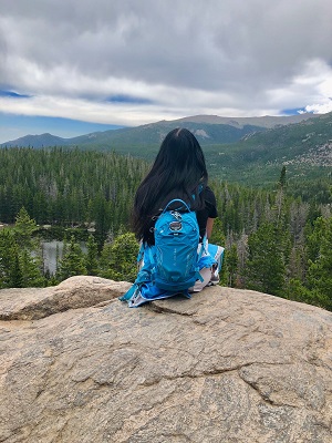
This is before the allergies kicked in. ;_;

There are tarantulas on the trail too, so if you have arachnophobia, well…here’s your warning. :D?

After we finally got through Jackass Trail, we took Poverty Flat Road to the China Hole Trail before following Manzanita Point Road back to our campsite at Sierra View.

It was worth getting through Jackass Trail to get to this though. <3


All in all, this hike was one of the most challenging ones I’ve been on thus far, but it definitely felt worth it when we managed to finish and return before sunset!

 Mount Sizer is one of the peaks in the Six Pack of Peaks Challenge! I’ve also hiked Mount Tam, Mount Diablo, and Rose Peak. Gotta get to Mount Umunhum and Mount Saint Helena one of these days!
- What’s the most difficult hike you’ve ever been on?
- What’s the steepest hill/mountain you’ve ever climbed?


32 comments
Skip to comment form
Looks like a beautiful place!
It was super pretty!
Can you believe I’ve never been shopping!!! It’s wild but true. I have heard of Henry Coe Park but I’ve never been, now I have to visit. Good luck with your Brothers Climb up Mount Whitney :) That sounds excited :)
hehe, my brother and his friends already went and it went well! They made it up and down and had a lot of fun! I wish I could’ve gone!
Farrah recently posted…Hiking the Mount Sizer Loop in Henry Coe State Park
Wish you could’ve gone too! You were badass at Henry Coe. That hike wasn’t easy and you kicked ass without a word of complaint. Great willpower.
Thank you! I was complaining on the inside with that 22% grade, ahaha. :P
Wow the trees and trails are beautiful! Looks like it was a lovely time!
It was tiring, but definitely worth it! :]
Hiking is my favorite outdoor activity! Thanks for sharing!
Briana
https://beyoutifulbrunette.com/
Anytime! It’s definitely one of my favorite outdoor activities too! :]
i would love to give on a hike, esp on a nice day!
This definitely would not have been fun on a day with crappy weather! x_x
That looks absolutely gorgeous! Minus that tarantula though. Yikes!
hahaha, at least we didn’t go during tarantula season! :P
This looks like a beautiful place! I haven’t been here yet, but I would love to go soon! Thanks for sharing!
I hope you get to go there sometime! :]!
What a beautiful place but it does look like a hard hike!
Definitely not an easy one, but it was worth it! (Beautiful views and we felt so accomplished afterward! :P! )
Farrah recently posted…Hiking the Mount Sizer Loop in Henry Coe State Park
Wow! Your photos are spectacular! (Except for the tarantulas – no thank you!!) I love hiking. Hmmm I think the hardest hike I ever did was in Cusco to Rainbow mountain it was super short (maybe 3 hours) and not very steep, but the elevation made it impossible.
Oooo, that sounds like a pretty hike though! I’ve never been to Peru, but it’s on my list! My brother went last year and had an amazing time!
What a beautiful hiking location!! I so wish I could go there this weekend! At least I got to virtually travel there through your blog post! <3
Aww, I hope you get to check it out sometime! <3!
I’ve actually been to this park before when we first moved to California two years ago! It’s totally beautiful but I didn’t know there were spiders, yikes o.o I don’t think I would have gone had I known that!!
The toughest hike I’ve ever gone on was in South Dakota! We hiked to the highest point in the state, Black Elk Peak. It was 3.5 hours and I was totally wiped afterwards!
Claire recently posted…Pregnancy FAQs: 20 Weeks
haha, I’m glad you found out after the fact then! :P
Ooo, South Dakota is part of my epic road-trip-back-to-the-west-coast plan! I’ll have to check out that hike!!
So pretty! I’m trying to imagine driving a car up a 22% grade, and um…I think i’d rather hike it?! I’d be afraid of the car flipping over! (Irrationally, but still.)
haha, I almost wanted to ask if I could jump into their car, but they seemed to be struggling just as much as i did!!
I love a good foggy, rainy hike. It’s always so green and not very crowded!
Agreed! I need to do these more often–it’s been a while!
Eeep for the tarantulas! The stats alone make this sound like a challenging trail! I mean 20 miles aaaand all that elevation gain!? I can totally see why you found it hard! Were there points when you had to scramble? Your photos make the trail look easy to walk along (even if it was steep… it doesn’t look technical) Or did you just put your cameras away during sections when you needed to scramble/climb?
I guess this was a while ago now. How did their ascent of Mount Whitney go in the end? That must have been tough!
Josy A recently posted…Valhalla Helicopter Tour – Kelowna
hahaha, forreals! It was a lot of fun though (other than the Jackass Trail portion, lol). I definitely put my phone away for the steep part. It wasn’t too technical, but just very slippery and steep. :O
They did it!! I was so jealous, haha. I’m hoping I can find a group to go with at some point but I definitely need to train more for it.
To climb Mt. Whitney, people need to score a permit on a lottery system – either for daytrips or an overnight stay. The chances of getting a permit is pretty low (20% for day permit; 14% for overnight permit), so we literally won the lottery… for a day permit.
The issue is that for a day permit, you have no time to acclimatize and you have to summit and return on the same day. We trained for about 3 months wearing weighted backpacks & climbing stairs in a parking garage. To date, that’s the most efficient method we’ve come up with. Our ascent was easy & uneventful, although we all felt the effects of altitude during the last 1,000 feet. Training paid off and it was beautiful & fun.
Still super jelly that you got to do that one, although I don’t know if I was in shape enough at the time to have completed it anyway. Glad you got to do it though–maybe I will someday as well! :O!!
Farrah recently posted…Ultimate Coffee Date: May 2023